


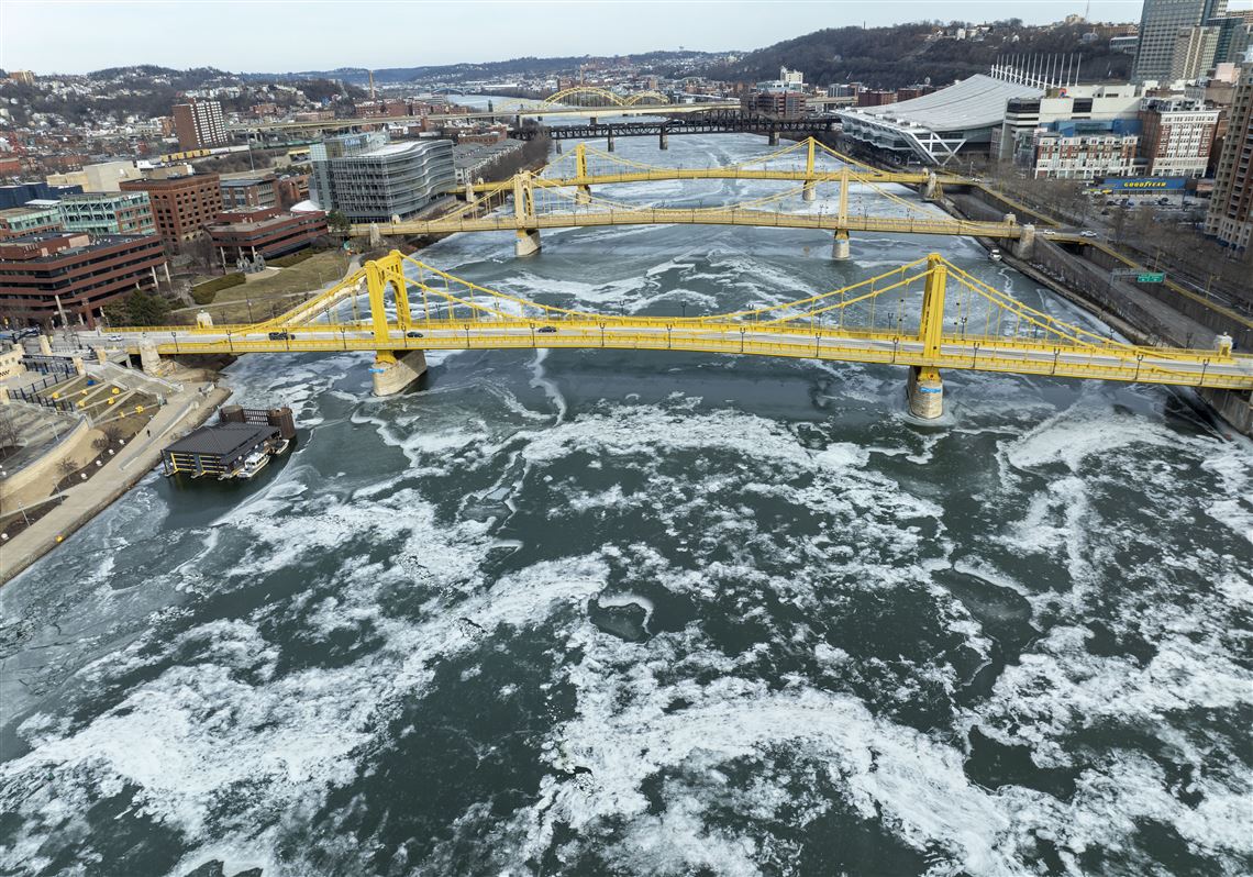
Warm temperatures and rain on Friday will continue to melt miles of ice sheets on portions of Pittsburgh’s three rivers.
The National Weather Service has issued a flood watch from 1 a.m. Friday through Saturday afternoon for higher elevations in Fayette and Westmoreland counties, and parts of West Virginia.
The service forecasted rapid rises in rivers from rain and snow melt that could cause ice jams and result in localized flooding.
In the Pittsburgh area, flooding is not expected.
Thursday’s high hit 49 degrees in Downtown Pittsburgh, with a balmy 54 degrees forecasted for Friday. In the Pittsburgh area, a half-inch to three-quarters of an inch is predicted for Friday.
The National Weather Service, the U.S. Army Corps of Engineers, the Coast Guard and the Waterways Association of Pittsburgh will continue to monitor conditions and river levels in Pittsburgh.
“We expect the combination of snow melt and water to cause rivers to rise, and faster-moving water will break up the ice,” said Jason Frazier, meteorologist with the National Weather Service in Moon.
There will be chunks of ice on the move.
An ice jam occurs when ice accumulates and sticks in one spot for some time, causing a backlog or a rise in the river.
“We don’t have that going on at this point,” Mr. Frazier said. The spate of warmer temperatures this week has caused the ice on the Pittsburgh rivers to thin, he said.
The Army Corps of Engineers, Pittsburgh District, is ready for the melting ice and higher water. All of its facilities remain operational on local rivers.
Five of its 16 reservoirs in the district located in southwestern Pennsylvania have 99.5% of their total flood-control capacity available, said Andrew Byrne, spokesman for the Army Corps of Engineers Pittsburgh District.
“As runoff from the winter weather continues, our reservoirs will make slow, calculated releases to ensure we continue mitigating flood risk without exacerbating ice formations,” he said.
The Corps cautions residents to stay clear of icy waterways.
“There's no way to guarantee how thick ice will be, especially in areas with moving water, such as rivers or streams,” he said.
The ice has caused delays and slowdowns for commercial boat traffic, said Shane Checkan, general manager of Industry Terminal & Salvage Co. and navigation committee chair for the Waterways Association of Pittsburgh.
The Allegheny River has been frozen bank to bank for about two weeks, precluding tug boat traffic, he said.
“We are looking at a different animal now — high water conditions and moving ice,” he said.
The high water will occur south of Pittsburgh and the Monongahela River basin, but not so much in the Allegheny River, he said. “Everybody is prepared.”
The public can report unusual formations of ice and flooding to the National Weather Service in Pittsburgh via social media on X (@nwspittsburgh) or via its website, weather.gov/pittsburgh/reports.
First Published: January 30, 2025, 10:46 p.m.
Updated: January 31, 2025, 6:11 p.m.