


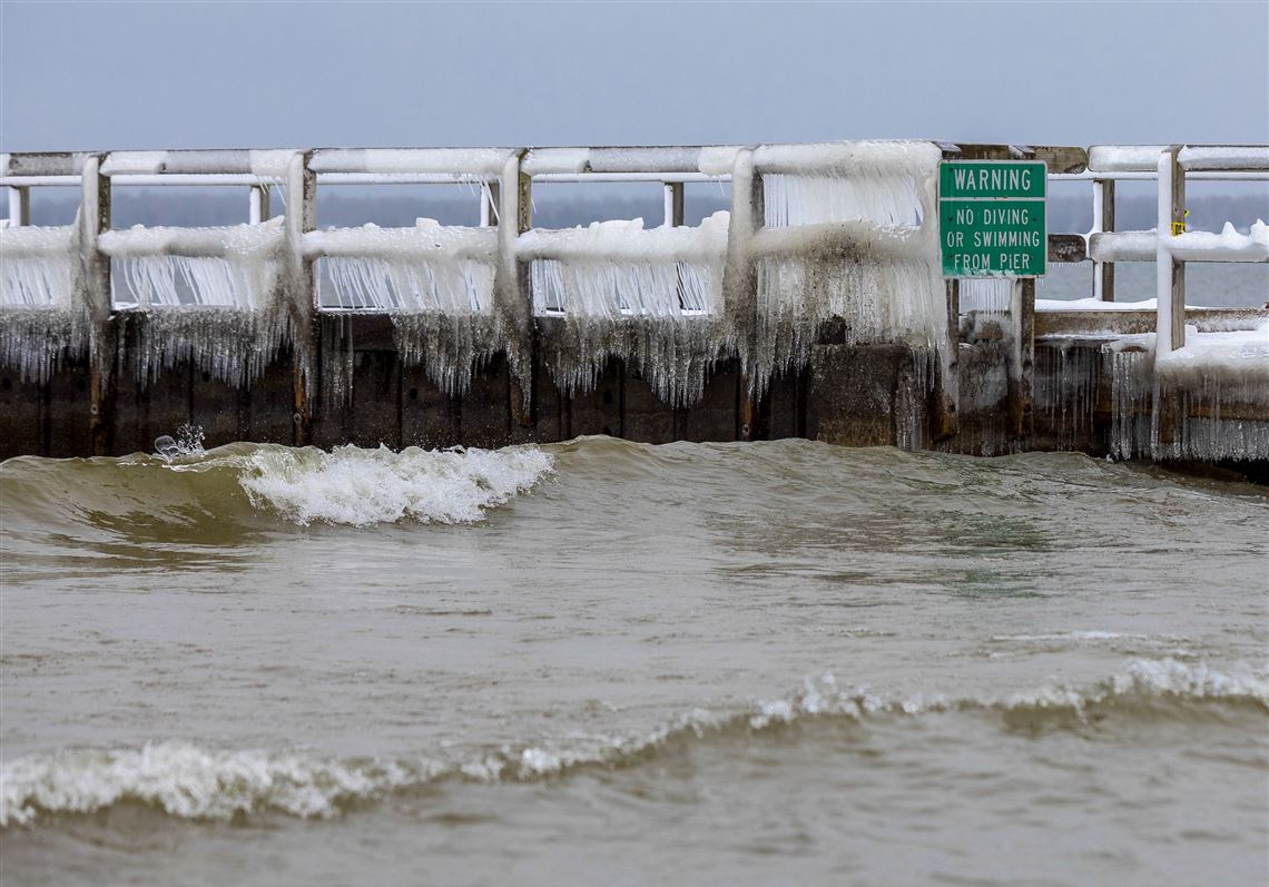
It’s late January, and less than 4% of the surface area of the Great Lakes is covered with ice. The lakes are almost entirely ice-free, and there’s not much to suggest that’s about to change soon. Water temperatures have been running anomalously above average, and relatively mild weather looks to stick around at least into February.
On Lake Erie, typically the most prone to significant freeze, only about 3% of the lake surface is covered by ice. That’s an uptick from the near-zero ice coverage that’s persisted virtually the entire season. The end of December featured a bit of ice developing, but it quickly broke up and melted.
Lake Ontario, meanwhile, is hovering at just above 1% ice coverage, while Lake Michigan, doubling that, still only sits a tad over 2%.
“Ice coverage is definitely below normal,” said James Kessler, a physical scientist with the National Oceanic and Atmospheric Administration’s (NOAA) Great Lakes Environmental Research Lab, in an interview.
Kessler said that the reduction in ice coverage is helpful for the Coast Guard, tasked with breaking the ice to allow shipping vessels across the lakes.
“But for recreation and ice fishermen . . . those people don’t like it,” he said.
Dwindling ice coverage is nothing new for the Great Lakes, with climate change and other factors contributing to about a 5% decline in maximum ice coverage per decade since records began in 1973. According to Mr. Kessler, Lake Superior is seeing the most rapid decadal decline in maximum ice coverage, falling at an average of 8.2% per decade.
He did note that significant year-to-year variability makes it difficult to draw conclusions about this winter so early in the season. Most places don’t ordinarily reach their maximum ice extent until late February.
“I will say it’s still pretty early in the year,” said Mr. Kessler. “When we talk about ice cover, we like to talk about maximum ice cover. It’s a good index.”
“There’s a huge amount of variability year to year in regards to that maximum ice cover,” he explained. “[During] the highest ice years, like 1979, almost all the lakes were 90% or higher. But in 2002, all the lakes were around 10% . . . [Lake] Huron got to 25%.”
Ice extent usually mirrors water temperatures. Though the coldest air temperatures are often found in January, it’s not until mid-to-late February and even into early March that water temperatures catch up.
Water temperatures this season are running several degrees above normal, coming off a summer that set numerous records. This has meant a delayed freeze.
But with warmer than average weather on tap for the foreseeable future and little in the way of major Arctic outbreaks, Mr. Kessler isn’t overly optimistic that any dramatic upticks in ice coverage are in the offing.
“Based on the latest forecast, Lakes Huron, Erie, and Ontario are predicted to be within the top 10 for lowest ice cover years,” wrote Mr. Kessler in an email.
In addition to affecting commerce, shipping and recreation, the lack of ice cover can influence the weather.
When water temperatures are anomalously warm, there’s more moisture in the air for lake-effect snow, which can bury parts of the shorelines of the Great Lakes in 100 inches or more of snow annually. That requires sufficiently cold air to be blowing over the water, however, which has been difficult to come by this season.
“Mainly because we haven’t had any sustained cold yet to get the lake effect machine up and running, our snowfall as a result is running below normal,” said John Boris, the science and operations manager at the National Weather Service in Gaylord, Mich., in a phone call. “In Sault Sainte Marie in the eastern [Upper Peninsula], by this date their normal snowfall is about 70 inches. So far this season, they’ve picked up 42.4.”
In Gaylord, where the office is based, seasonal snowfall is running just over half of the 80 inches typically seen by this point in the year.
“And our snow depth, too,” Mr. Boris said. “We just got above 10 inches this week. Often we’re above that in November and December . . . it speaks to the lack of cold air [needed to] keep the lake effect going.”
At the nearby Weather Service office in Marquette, meteorologist Matt Zika reported similar conditions.
“Many lake effect snow belts are running snowfall departures from normal that will be impossible to make up,” he wrote via email.
The weather has been relatively mild, and may in fact break records.
“After a chilly and snowy October, most of the Upper Great Lakes have been dealing with a record warm start to the winter,” wrote Zika. “November average temperatures were 5.8 degrees above normal, December 5.7 degrees above normal, and January so far [has been] 10.3 degrees above normal. Ski hills and the snowmobiling tourism industry have been impacted by the lack of snow to date.”
First Published: January 22, 2021, 4:08 p.m.